CONFERENCE
Company Profile of the Institute of Geodesy and Geoinformation University of Latvia
The Institute of Geodesy and Geoinformation is a research & development unit of the University of Latvia. The Institute consists of two departments:
Department of Geodesy and Department of Geoinformation. The main topics of the activities are:
Department of Geodesy –
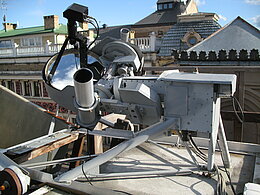
- Construction of Satellite laser ranging systems (hardware, software)
- GNSS applications,
- Participation in the project EUPOS®
Department of Geoinformation –
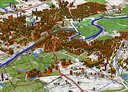
- Development of 2D and 3D country-wide geographical databases,
- Development of large urban geographical databases and DEM,
- Development of highly detailed local geographical databases.
The Department of Geodesy has experienced staff dealing with satellite on ground observations; the hardware and software has been designed for this purpose. Currently several projects are being carried out on the issues of research and development.
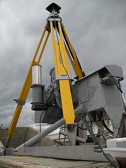
Construction of automated zenith telescope for the vertical deflection is under development. The project is named “Digital zenith telescope for the gravity field anomalies detection”. Contract No. 2010/0207/2DP/2.1.1.1./10/APIA/VIAA/077.
- ERAF 2.5.1 Project “Component of the Geographical Information System for Latvian economy”. Contract No.VPD1/ERAF/CFLA/05/APK/2.5.1./000081/039
- EUREKA supported “E3095! EULASNET LEO SATELLITE” Low Earth Orbiter Satellite Observation. The pilot project of the SLR machine is under development
- INTERREG III C East Project „European Position Determination System – Interregional Co-operation” 4E0026I – EUPOS – IRC.
- The Riga multifunctional GNSS positioning system is "EUPOS® - RIGA" the joint project with “Riga’s GeoMetrs”.
- GIS and GNSS education and training.
- The international symposium “European Galileo Information Days in Riga, 12-13 May 2005” has been organized by the Department of Geodesy jointly with Galileo Point of Polish Space Research Institute.
Activities in geomatics at the Department of Geoinformation. Research on GIS development trends and strategies in Latvia:
- “development of revisory map of TNT-T network improvement in Latvia”
- analysis of actual trends in national GIS developments
- drafting the national strategy for GIS development
Development of proprietary GIS software:
- development of low-cost mini-GIS software (discontinued now)
Development of 2D geographical databases (digital maps):
- development of country-wide geographical databases
- development of large urban geographical databases
- development of highly detailed local geographical databases
Development of 3D geographical databases (digital elevation models):
- development of country-wide digital elevation models
- development of digital elevation models for urban areas
Development of complete GIS’s.
Application of GIS techniques to specific practical tasks:
- computation of Latvia's economic exclusion zone
Many projects have been developed by skilled personnel in digital mapping and GIS by using ESRI and ERDAS software.